Driving Through Irbil Province, Part I
My apologies for not posting much lately. The State Department's computer problems have not been fully resolved, and it takes forever to download the included pictures on the TrailerNet. But also, as I warned in my very first post back in January, I've been a little lazy lately.
Herein are some notes and observations, in almost no particular order, about the drive from Salahaddin to, well, where ever it was we ended up having lunch . . .
-- The convoy of 20-30 White Toyota Land Cruisers takes off with me sharing a vehicle with another aide to the Ambassador (an Iraqi-American who is beloved by the Kurds) and a young political officer from the Embassy. We pass through Kurdish mountain villages, some with small convenience stores, although more frequently we pass roadside stands with jugs of gasoline and cans of motor oil for sale. (This despite the fact that every gas station we pass is closed -- welcome to the world of subsidized commodities and the black markets that supply and demand inevitably create).
-- The roads, for the most part, are choppy and poorly paved. We pass numerous Kurdish children, far more than adults. This is likely the result of Saddam's attempted genocide against the Kurds in 1987-88, as well as the massacres in the wake of the First Gulf War in 1991, and the subsequent baby boom after the Kurdish region became autonomous with the advent of the No-Fly Zones. The boys invariably wear Western-style clothes, whereas the girls are more likely to be wearing native dress. Regardless of how they are attired, they invariably wave at us as we pass, and are adorable.
-- The slopes gradually become steeper, with granite cliffs appearing in the distance. We drive through green valleys with views of some spectacular gorges and cuts in the mountain sides. Near Mama Jalka, we come around a bend in the road and see eight fruit stands on the "shoulder."
-- In one little village, there is a fenced-in soccer field with artificial turf laid over what was likely once a tennis court. In another village, a basketball court sits at the base of a mountain, except the court is covered with mounds of feed.
-- Whenever we drive through a village or cluster of houses, the residents stop to look at the convoy as it creeps along the main road. It is more than likely the people know whose convoy it is . . . after all, how many 30 vehicle convoys are there in Kurdistan?
-- Near Korak Mountain (distinctive for the observatory perched at the peak) we pass a Pesh Merga barracks. The flag flying above the compound is Kurdish rather than Iraqi, with three red, white, and green stripes, with a sun sitting in the middle.
-- About an hour out from Salahaddin the road weaves through a cut in the mountain, with sheer granite slopes on either side, and a crystal blue mountain stream snaking alongside. Families are parked and picnicking near a small waterfall, in one of nearly a hundred stalls set up by the stream.
-- We pass fewer mosques on the outskirts of Salahadin then one would see over a similar distance in/near Baghdad, although later in the day they will become more frequent in the smaller rural villages. Kurdish mosques are also much less ornate than those I've seen in Baghdad, Amman, Doha, or Kuwait. The minarets are smaller, and if they even have domes, they are simple and less adorned.
-- We pass through Shaqlawa (not, as it turns out, an homage in any way to Shaquille O'Neal) a larger village with a crowded marketplace at the intersection of two roads in the center of town. The stands are filled with watermelon and cantaloupe, one store has a Western-style wedding gown on display outside. A few feet away, a pickup truck is parked with three goats tied up in the flat bed.
-- After Shaqlawa, the terrain opens into a massive valley of tan hills dotted with dark green trees on the slopes. The hills become steeper, and the two-lane highways becomes a series of hairpin turns. Roadsigns show cars driving off the mountainside as a reminder to motorists to watch their speed.


Some pictures of the Kurdish countryside, although they hardly do justice to the beauty of the scenery.
-- After some time, the convoy splits in two, with the VIPs and staff literally taking the high road while the attendants and extra security vehicles stay on the main road. We travel up an unpaved, one-lane road, and looking out the window I can see the ground drop precipitously just a few feet from the side of the SUV. Nevertheless, our driver continues to go about 80 Kph (roughly 45 mph) in order to keep up with the lead vehicles. Shepherds' tents are scattered along the mountainside. The convoy stops, and we get out of our Land Cruisers. Massoud Barzani points across a beautiful valley to some snow-covered peaks. (By way of comparison, it is over 110 degrees in Baghdad). Those mountains, he tells Ambassador Khalilzad and Dr. Allawi, are in Iran. To the northwest, at about an equal distance, we can see the outlines of peaks within the Turkish border.

Some of the shepherd encampments on the mountainside.

The snowy peaks in the distance are in Iran.

And the hazy peaks visible in the distance are in Turkey.
-- One of the Ambassador's security detail starts to move down the slop in order to take a picture of the entourage. The Pesh Merga quickly yell for him to stop, and to return to the group by retracing his steps. The reason? Landmines.
Herein are some notes and observations, in almost no particular order, about the drive from Salahaddin to, well, where ever it was we ended up having lunch . . .
-- The convoy of 20-30 White Toyota Land Cruisers takes off with me sharing a vehicle with another aide to the Ambassador (an Iraqi-American who is beloved by the Kurds) and a young political officer from the Embassy. We pass through Kurdish mountain villages, some with small convenience stores, although more frequently we pass roadside stands with jugs of gasoline and cans of motor oil for sale. (This despite the fact that every gas station we pass is closed -- welcome to the world of subsidized commodities and the black markets that supply and demand inevitably create).
-- The roads, for the most part, are choppy and poorly paved. We pass numerous Kurdish children, far more than adults. This is likely the result of Saddam's attempted genocide against the Kurds in 1987-88, as well as the massacres in the wake of the First Gulf War in 1991, and the subsequent baby boom after the Kurdish region became autonomous with the advent of the No-Fly Zones. The boys invariably wear Western-style clothes, whereas the girls are more likely to be wearing native dress. Regardless of how they are attired, they invariably wave at us as we pass, and are adorable.
-- The slopes gradually become steeper, with granite cliffs appearing in the distance. We drive through green valleys with views of some spectacular gorges and cuts in the mountain sides. Near Mama Jalka, we come around a bend in the road and see eight fruit stands on the "shoulder."
-- In one little village, there is a fenced-in soccer field with artificial turf laid over what was likely once a tennis court. In another village, a basketball court sits at the base of a mountain, except the court is covered with mounds of feed.
-- Whenever we drive through a village or cluster of houses, the residents stop to look at the convoy as it creeps along the main road. It is more than likely the people know whose convoy it is . . . after all, how many 30 vehicle convoys are there in Kurdistan?
-- Near Korak Mountain (distinctive for the observatory perched at the peak) we pass a Pesh Merga barracks. The flag flying above the compound is Kurdish rather than Iraqi, with three red, white, and green stripes, with a sun sitting in the middle.
-- About an hour out from Salahaddin the road weaves through a cut in the mountain, with sheer granite slopes on either side, and a crystal blue mountain stream snaking alongside. Families are parked and picnicking near a small waterfall, in one of nearly a hundred stalls set up by the stream.
-- We pass fewer mosques on the outskirts of Salahadin then one would see over a similar distance in/near Baghdad, although later in the day they will become more frequent in the smaller rural villages. Kurdish mosques are also much less ornate than those I've seen in Baghdad, Amman, Doha, or Kuwait. The minarets are smaller, and if they even have domes, they are simple and less adorned.
-- We pass through Shaqlawa (not, as it turns out, an homage in any way to Shaquille O'Neal) a larger village with a crowded marketplace at the intersection of two roads in the center of town. The stands are filled with watermelon and cantaloupe, one store has a Western-style wedding gown on display outside. A few feet away, a pickup truck is parked with three goats tied up in the flat bed.
-- After Shaqlawa, the terrain opens into a massive valley of tan hills dotted with dark green trees on the slopes. The hills become steeper, and the two-lane highways becomes a series of hairpin turns. Roadsigns show cars driving off the mountainside as a reminder to motorists to watch their speed.
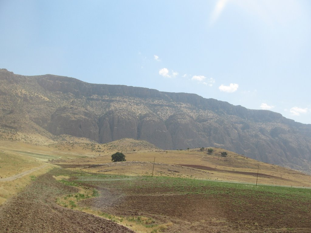
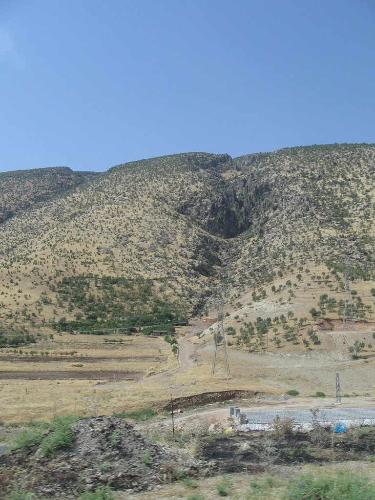
Some pictures of the Kurdish countryside, although they hardly do justice to the beauty of the scenery.
-- After some time, the convoy splits in two, with the VIPs and staff literally taking the high road while the attendants and extra security vehicles stay on the main road. We travel up an unpaved, one-lane road, and looking out the window I can see the ground drop precipitously just a few feet from the side of the SUV. Nevertheless, our driver continues to go about 80 Kph (roughly 45 mph) in order to keep up with the lead vehicles. Shepherds' tents are scattered along the mountainside. The convoy stops, and we get out of our Land Cruisers. Massoud Barzani points across a beautiful valley to some snow-covered peaks. (By way of comparison, it is over 110 degrees in Baghdad). Those mountains, he tells Ambassador Khalilzad and Dr. Allawi, are in Iran. To the northwest, at about an equal distance, we can see the outlines of peaks within the Turkish border.
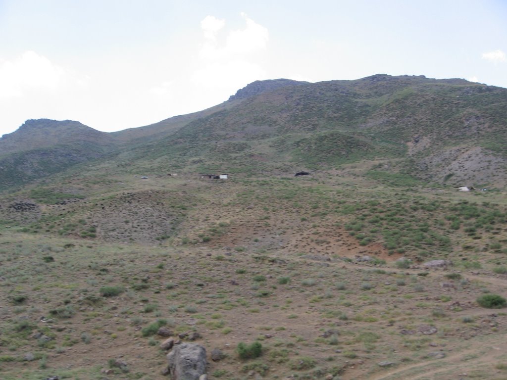
Some of the shepherd encampments on the mountainside.

The snowy peaks in the distance are in Iran.
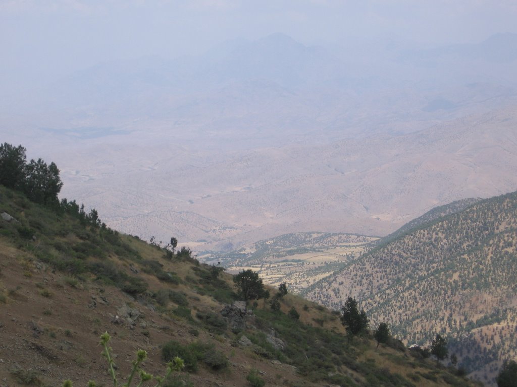
And the hazy peaks visible in the distance are in Turkey.
-- One of the Ambassador's security detail starts to move down the slop in order to take a picture of the entourage. The Pesh Merga quickly yell for him to stop, and to return to the group by retracing his steps. The reason? Landmines.
posted by Ben at 3:26 PM
![]()
![]()

<< Home